Minneapolis is covered in many areas with lots of bike lanes and trails, but ironically the places with the highest concentration of destinations themselves are surprisingly devoid of any bike infrastructure: not even a “share the road” sign or the lowly “sharrow”: Hennepin, Lyndale, and Lake are just a few examples. They’re chock full of destinations, yet they’re only easy in parts to bike to, not on. Not everyone is a vehicular cyclist like me who has no issue biking a few blocks on Hennepin taking the right lane and traveling fast enough to keep up with traffic slowed by the cars in front of me. The other 99% aren’t biking on these streets and there’s no amount of paint that would persuade them to do so otherwise. Cycle tracks are another option and would increase the number quite a bit more, but limited space, and even less willingness to sacrifice parking/travel lanes for motorists, even temporarily, means lots of opposition, so we should consider an alternative we can all agree on: put cyclists up in the sky.
If you’ve ever been to Chicago and ridden the L’s Red Line then you know there are some kick-ass views of the city from up there: why don’t we want to experience Minneapolis in a similar light without the hassle and cost of building a subway system, elevated at that, around Downtown and the Uptown/Lyn-Lake area? The answer: the elevated bike-lane. London is planning the 1st of ten such routes which will take a total of 20 years once it breaks ground who knows when and will cost around $300 million for 3.75 miles. It’s predicted to cut commute times by 50%: you gonna sit in traffic for 45 minutes getting from Uptown to Downtown or are you going to ride your bike over them belting out a hearty Nelson-like “Ha! Ha!” at all the people sitting in their cars crawling at walking speed below?
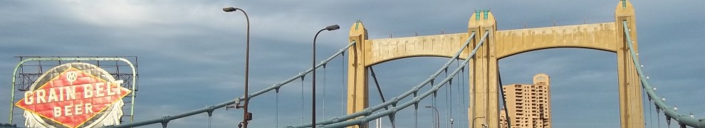
Where would our starter elevated bike lane make the most sense? Downtown is a contender: just think of all the awesome photos you could take and the huge surge of instagrams of people riding by the rooftop bars on Hennepin (Union, Solera, Seven, Crave) and Nicollet (Brit’s Pub) with the requisite angled views of the streets and skyscrapers in the background. It could connect to the Cedar Lake Trail and Stone Arch Bridge to the north and .And yes, this will bring tourists: lots of ’em…and get us a good chunk of those 100,000 new residents we’re clamoring for. Which of these scenarios is realistic? “I’m moving to Mpls because they’re building a new LRT line to burbs and a streetcar line in the city.” vs. “I’m moving to Mpls because they’re building a bike highway in the motherfuckin’ sky.” And just think of how well this would compliment our downtown skyways: we’ll look like a proper 22nd century city with all those levels of walkways and bikeways crisscrossing the skies above us. Not even NYC could compete with that.
The other option is a Hennepin-Lake-Lyndale route which is obvious not only for its favorable rooftop patio ratio along its length, but because it would directly connect to our existing and successful below street-level bike highway via the Chain of Lakes trails and the Loring Greenway to the north. Here’s a very rough draft of what we’d have if we go this route and spend almost as much as London (if the actual cost in addressing everything to get this built actually translates smoothly).
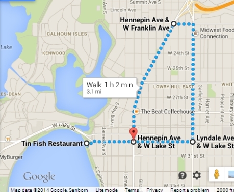
Note that when I tried to make this with the cycling option on Google Maps it wouldn’t let me go down Hennepin no matter how much I tried, hence the need to switch to pedestrian mode: getting the hint there City of Minneapolis?
We’re currently looking at sinking $200 million on a Nicollet-Central Ave streetcar and in the process pissing off a lot existing businesses, customers, motorists, transit riders and even cyclists who will have to make a detour due to tearing up these streets for several months and removing *gasp* lots of parking spaces and a travel lane. I thought the whole reason the city is so reluctant to put bike lanes on its densest commercial corridors (hello Lake Steet) is because of the opposition from motorists and business demanding they always maintain access to more than one travel lane and on-street parking, so color me confused that they’re poised to ignore them for a streetcar, but not for bikes. Now if instead that $200 million were allocated to an elevated bike highway there would be not a single parking space or travel lane lost and the other 99% of people who won’t bike up and down Hennepin would now have a bikeway just like the Midtown Greenway except it’s above the street and directly connects to the rest of Hennepin, Lake, and Lyndale. It would likewise have much higher ridership than on-street infrastructure: maybe even higher than the Midtown Greenway due to entirely serving dense clusters of destinations. It would be superior to bike lanes, bike boulevards, or even a cycle-track since it completely removes intersection conflicts between motorists and cyclists rather than merely minimizing the risk: again just like much of the Midtown Greenway does.
If we were to go even further they could instead be elevated Multi-Use Trails: think the “Uptown Greenway” and “Downtown Greenway”. So that’s my “big plan” to kill two birds with one stone: give residents the chance to see this city like never before and actually get lots people out of their cars on onto their bikes, not this chump change 5% of Mpls residents who now bike as their main form of transportation. Cyclists would clearly be for this. Motorists would be more than for this to keep their parking spaces and plentiful lanes intact. Businesses not wanting to risk experimenting to see if lack of on-street parking and detours kill them would be for this. We’ve already proven a bike highway is successful with the Midtown Greenway: what difference would make that it’s above the street rather than below? And why are we not at the ribbon cutting ceremony already?
The one thing you can do today to sort of experience an elevated bikeway/greenway over Lyndale is to cross the Loring Bikeway Bridge over Lyndale and think just how cool it would be if you could take an exit and there another the path continued down south. That would be pretty damn great, wouldn’t it?